
Numbers and geography. Neither, as my family never tires of pointing out, is exactly my strong suit. A spreadsheet? My eyes glaze over instantly. Need directions? You’re better off staying home than listening to me. Maps, however, are a bit of a different story. Maybe it’s because a good map does the hard work for you. Take a pile of data that would normally send me running, add a few colors, and suddenly order is restored to the world (or at least the part of it on the map). And it’s not all navigation, either.
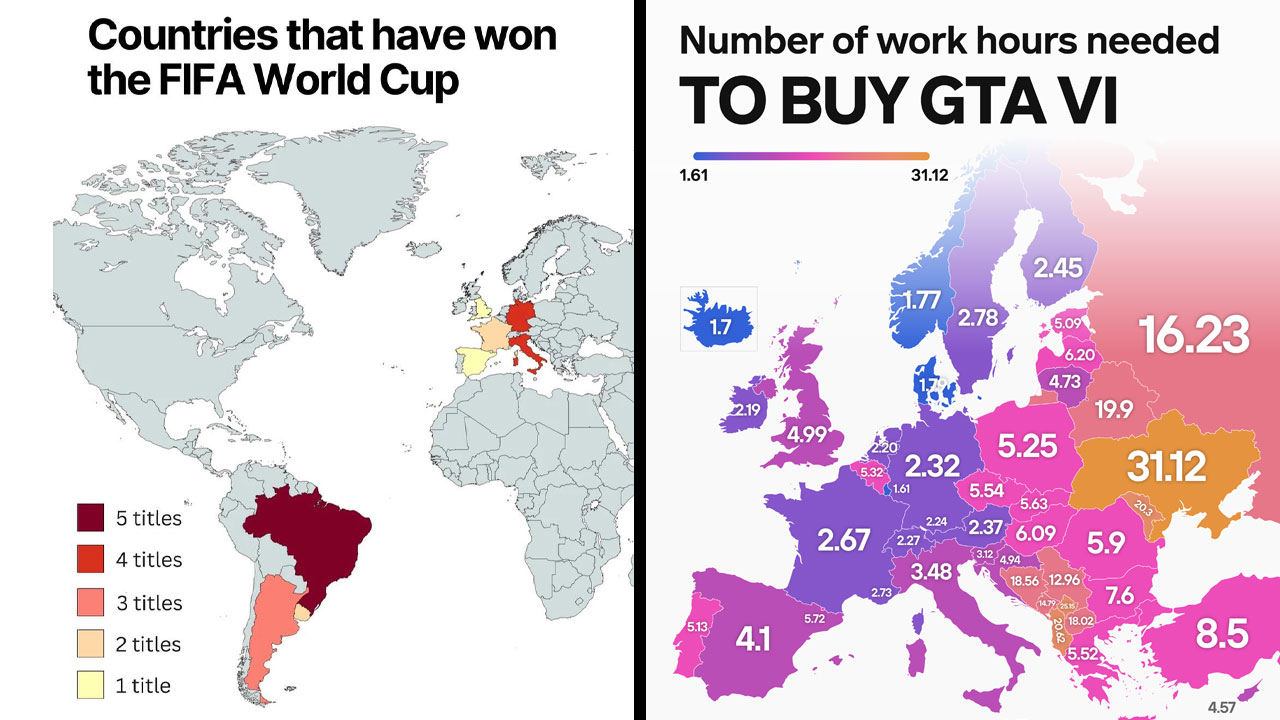
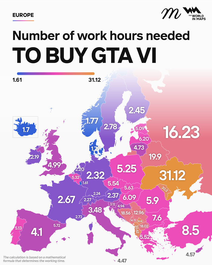
Turns out some maps even reveal all sorts of curiosities you never knew you wanted to know about, like which European countries use a comma instead of a decimal point, where it’s illegal to boil a lobster alive, or how many hours you’d have to work to buy GTA VI, depending on where you live. So whether you’re a geography buff or someone who, like me, still gets lost on the way to the shops, here are some of the most fascinating maps out there, plus some expert insight from Philippa Irvine, a geography lecturer at Rhodes University in South Africa.
#1 I've Drawn Manhattan With One Line That Never Intersects [oc]
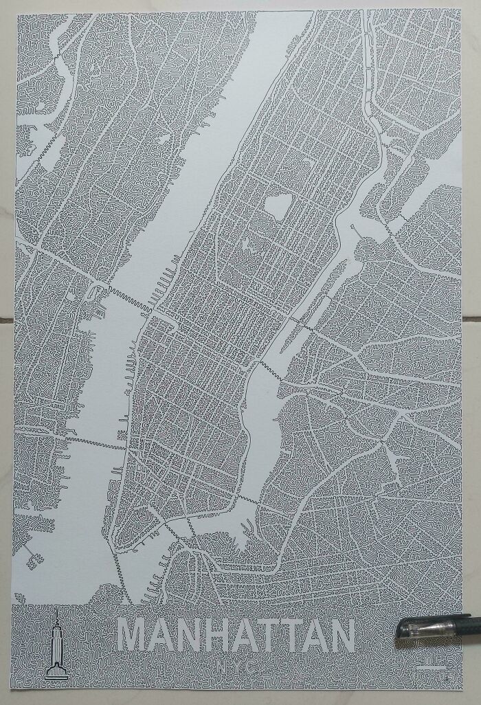
© Photo: The-bubator
#2 World Blocks By Population (2b Each)
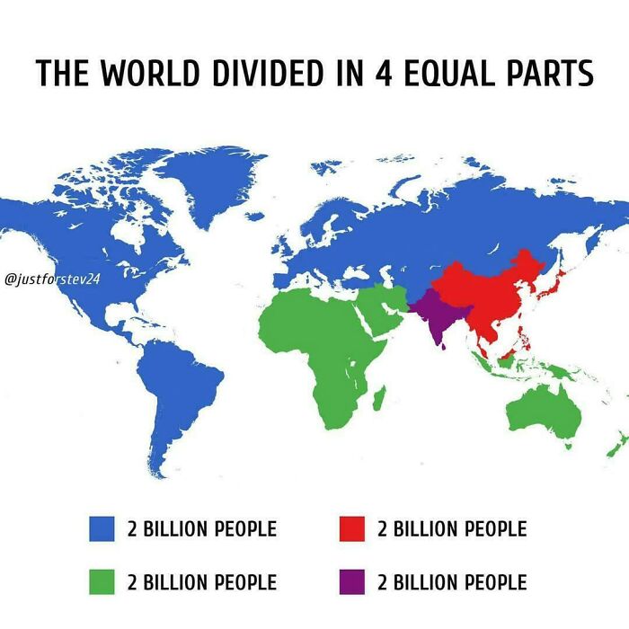
© Photo: aNonYmoUs_gLideR
#3 The Sahara Today vs. 8 Thousand Years Ago
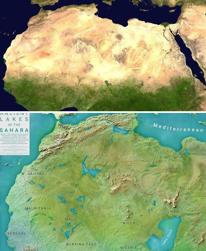
© Photo: Fokabaszo_Fingbag
Not too long ago, a friend of mine shared a photo on Facebook of a stack of old maps she’d been gifted. Her caption? “Someone just spoke my love language.” If you’re reading this post, you can probably relate. But even if you aren’t a certifiable cartophile, you have to admit that there’s something pretty delightful about maps, whether they’re the old-school paper kind or their modern digital (even interactive!) counterparts.
Sure, they’re a useful tool for getting around, especially if you’re geographically challenged, like me. But as Esri, the company behind the ArcGIS mapping software, puts it, “Maps are more than diagrams that help you navigate from point A to point B.” They can help us visualize data, spot trends, and, perhaps most importantly, spark curiosity.
#4 70% Of Canada's Population Lives In These Three Regions
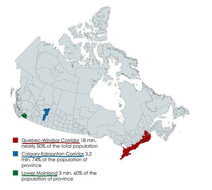
© Photo: Youtubegoy229
#5 Australia's Highway 1 Is The World's Longest National Highway
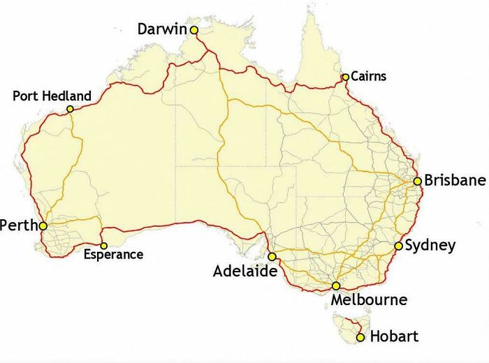
© Photo: vladgrinch
#6 Countries Where Oranges Are Called ''portugal''
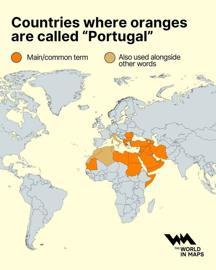
© Photo: vladgrinch
And they’ve been helping us do this for a very long time. According to National Geographic, some of the oldest known maps are clay tablets from ancient Babylon. Maps have come a long way since then. These days, making a pretty sophisticated-looking one takes little more than some data and free software, no clay or map-making experience needed.
#7 Polynesian Shell Map
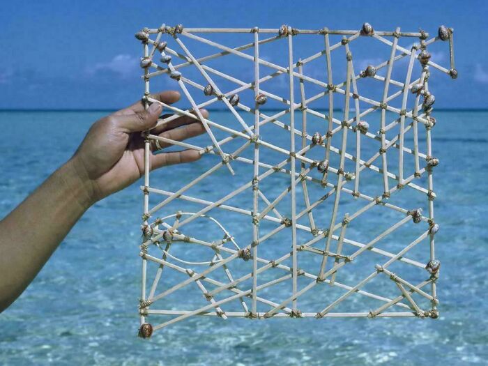
© Photo: StephenMcGannon
#8 What A 5,000 Km Radius Around Paris Looks Like On A Mercator Map
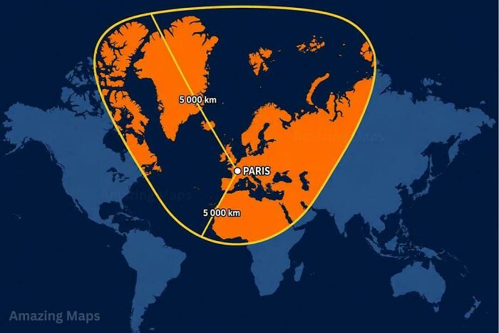
© Photo: vladgrinch
#9 I Made A Map Of The United States Using Actual Soil From All 50 States
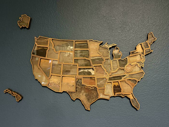
© Photo: AMLT1983
And if you’ve ever thought every map worth making has already been made, think again. As Esri points out, “What about a map of the earthquake that happened earlier this morning? Our world is constantly changing, and we will never run out of things to map.” That’s good news for professional cartographers (making maps is, after all, kind of their whole job). But it’s also good news for the countless people who make maps simply because they love it.
#10 Europe's Currencies Before The Euro
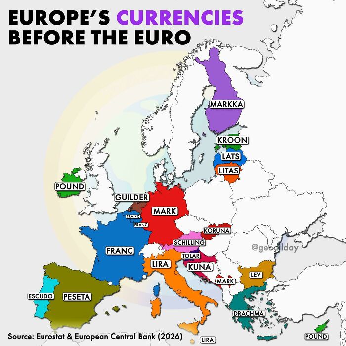
© Photo: BeginningMortgage250
#11 South America Is Much Bigger Than Most People Realize
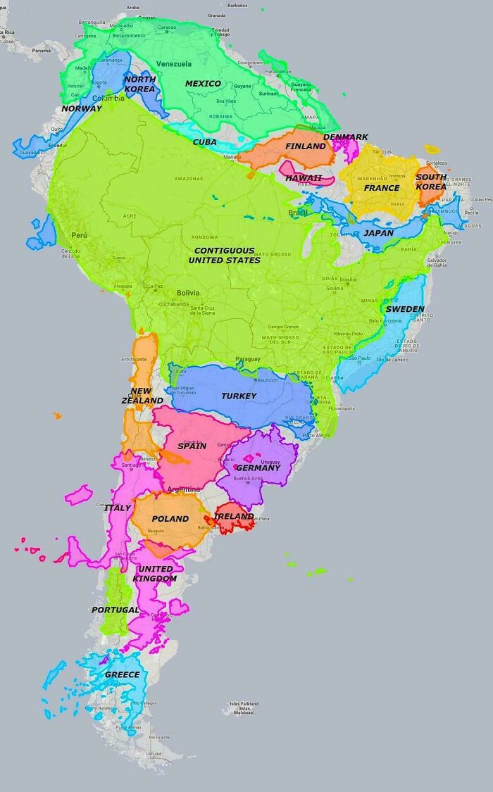
© Photo: vladgrinch
#12 Language Map Of Switzerland, Excluding Uninhabited Mountains
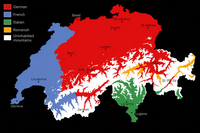
© Photo: Evilgrandma03
Science journalist and geologist Betsy Mason is one of them. In a piece for Wired, she recalls looking for any excuse to make a map as a kid. Alongside maps of her real home, school, and neighborhood, she drew the ones she wished she had, complete with stables full of horses, fields of frogs and praying mantises, and entire rooms for storing stuffed animals. She even counts the maps she got to make in Geology 101 among the reasons she became a geologist.
#13 Lithuania At It's Historical Peak (15th Century) Also Known As Grand Duchy Of Lithuania, It Expanded Up To 900,000-100,000 Sq Km
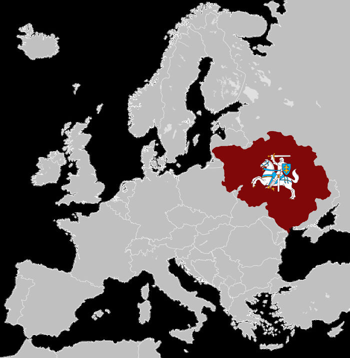
© Photo: banamkae
#14 Canada vs. Europe Latitude (Oc)
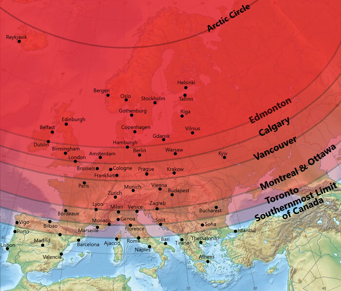
© Photo: Aijol10
#15 Europe On Google Earth, But It's The 17th Century
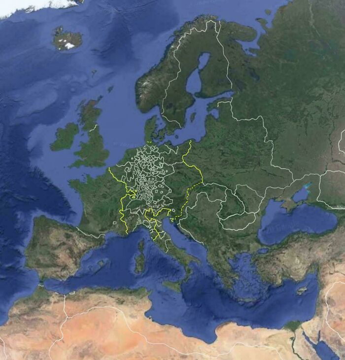
© Photo: tightypp
So what is it about making maps that she loves so much? Mason admits she’s not entirely sure. Sometimes, she says, it’s the order of it all, “putting everything precisely where it is supposed to be,” or the satisfaction of methodically turning a bunch of data into “something tangible, maybe even useful.” Other times, it’s the way maps help her think about things in relation to each other “in a way my brain isn’t always good at doing on its own.” And then there are the possibilities. Just as maps help her make sense of things that exist, “they can help me imagine things that don’t.”
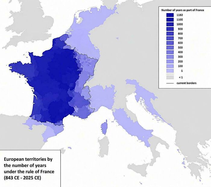
#16 How Long Different Parts Of Europe Were Ruled By France
© Photo: vladgrinch
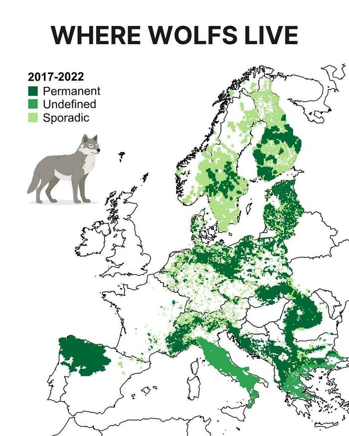
#17 Where Wolves Live In Europe
© Photo: hernancb21
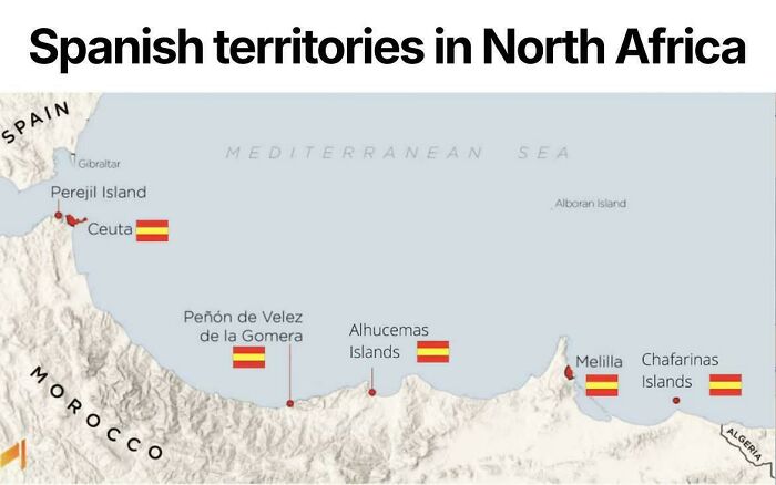
#18 Spanish Territories In North Africa
© Photo: vladgrinch
Mason is far from alone. Geography lecturer Philippa Irvine (who also happens to be my friend with the stack of old maps) knows the feeling well. “I enjoy the logic of it but also the creativity,” she told Bored Panda. “The need to marry information with composition and legibility makes it somewhere between science and art.”
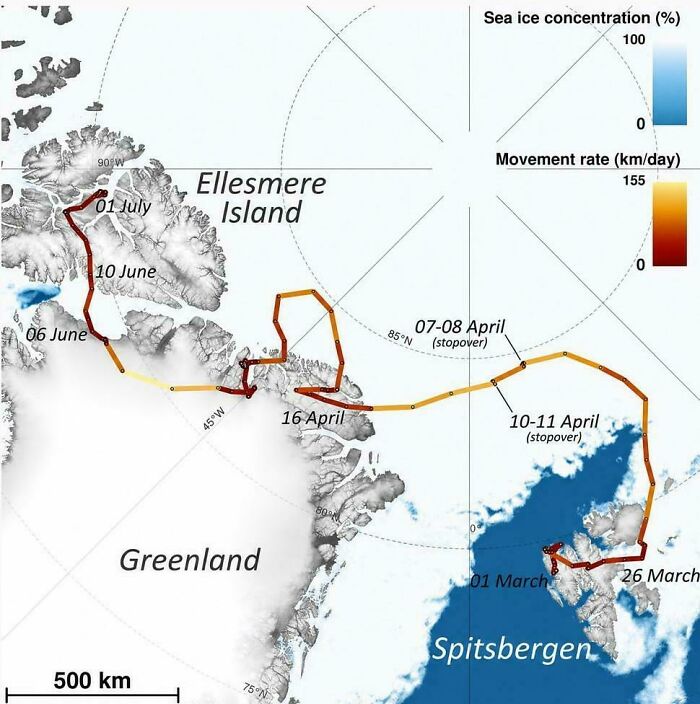
#19 An Arctic Fox Walked From Norway To Canada In 76 Days
© Photo: vladgrinch
#20 Holland vs. The Netherlands
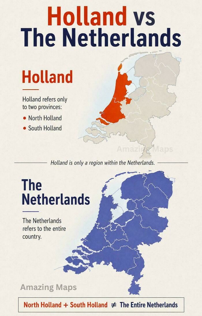
© Photo: vladgrinch
#21 The Countries That Have Banned Boiling Lobsters Alive
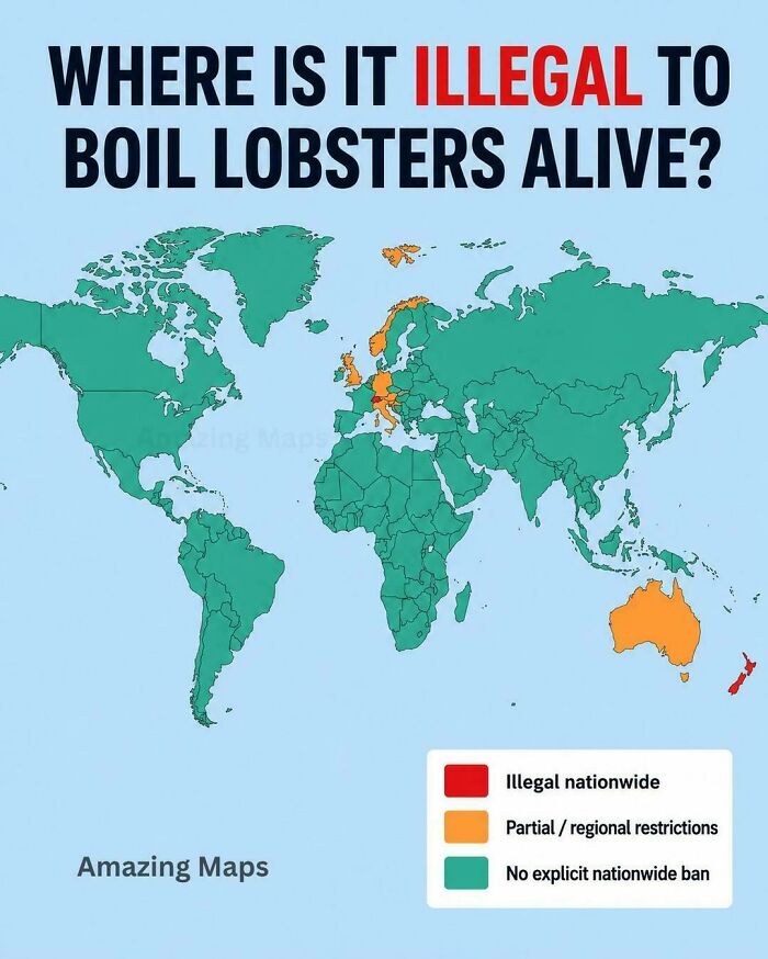
© Photo: vladgrinch
That combination is part of what makes maps so powerful. “Maps reveal spatial relationships, whether it’s distance, areal coverage, density or clustering,” Irvine explains. But they can also show “what is important to planners, communities and cultures,” from how a city is laid out to how its land is used.
#22 Countries By How Many Women Attend University Education Compared To Men
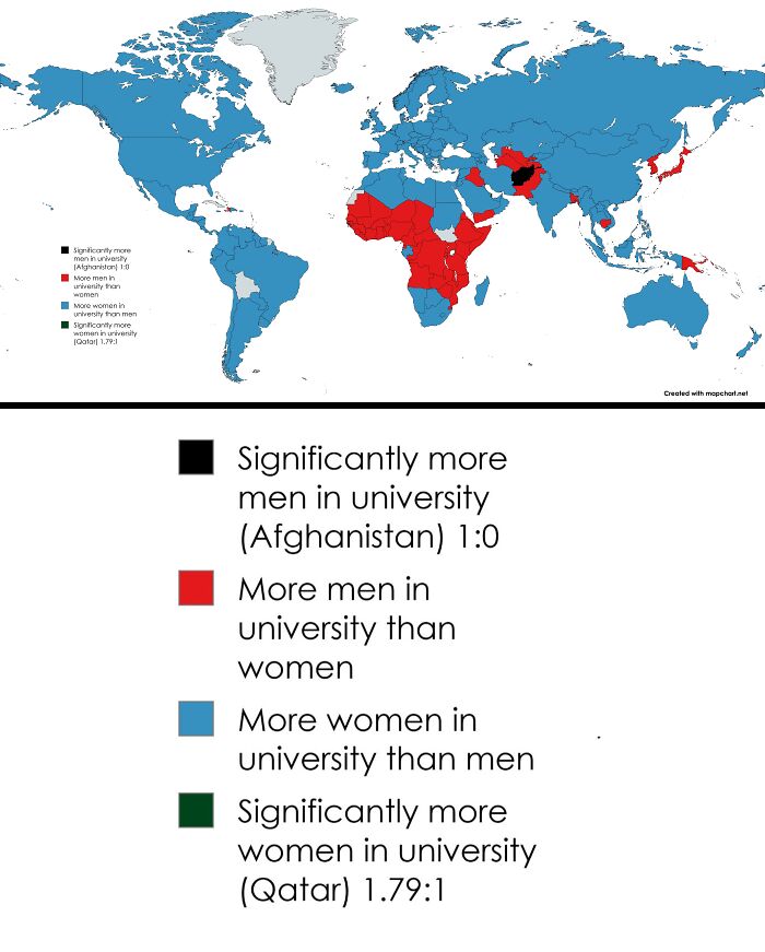
© Photo: AntiqueBrick7490
#23 The Oldest Continuously Operating Universities In Each European Country
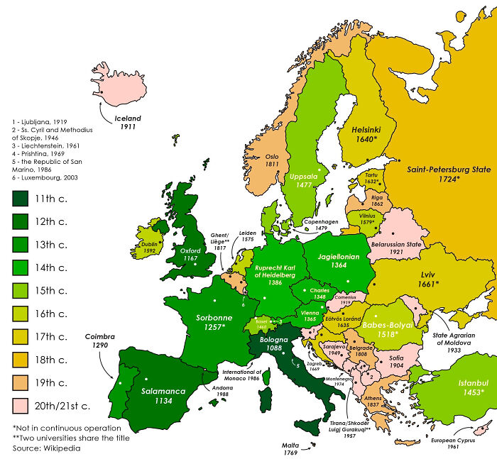
© Photo: InnerPace
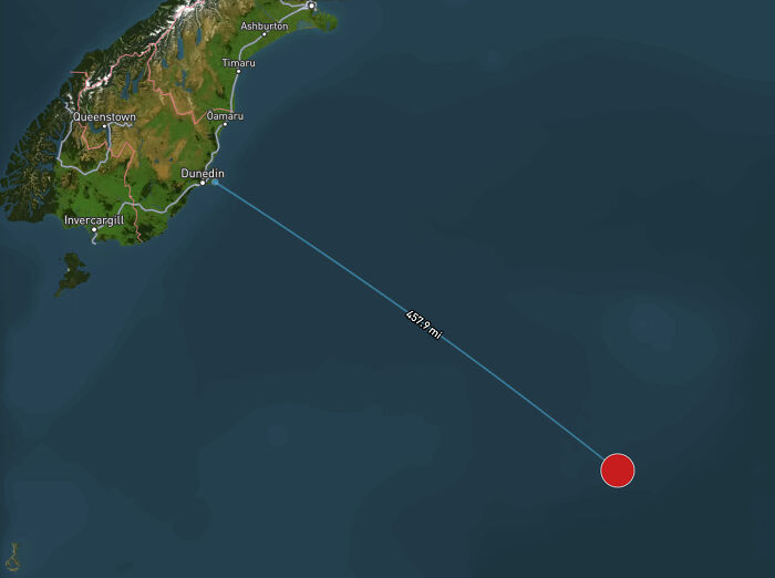
#24 The Most Isolated Building On Earth
© Photo: mbforr
And that’s the thing about maps: they’re never just a neutral picture of the world. Every one involves choices—and that’s where things get a little tricky. As geographer Mark Monmonier famously wrote, “Not only is it easy to lie with maps, it’s essential.” Squeezing a round, three-dimensional world onto a flat page or screen means something has to give. So, he argues, even an accurate map has to tell a few “white lies” to be useful.
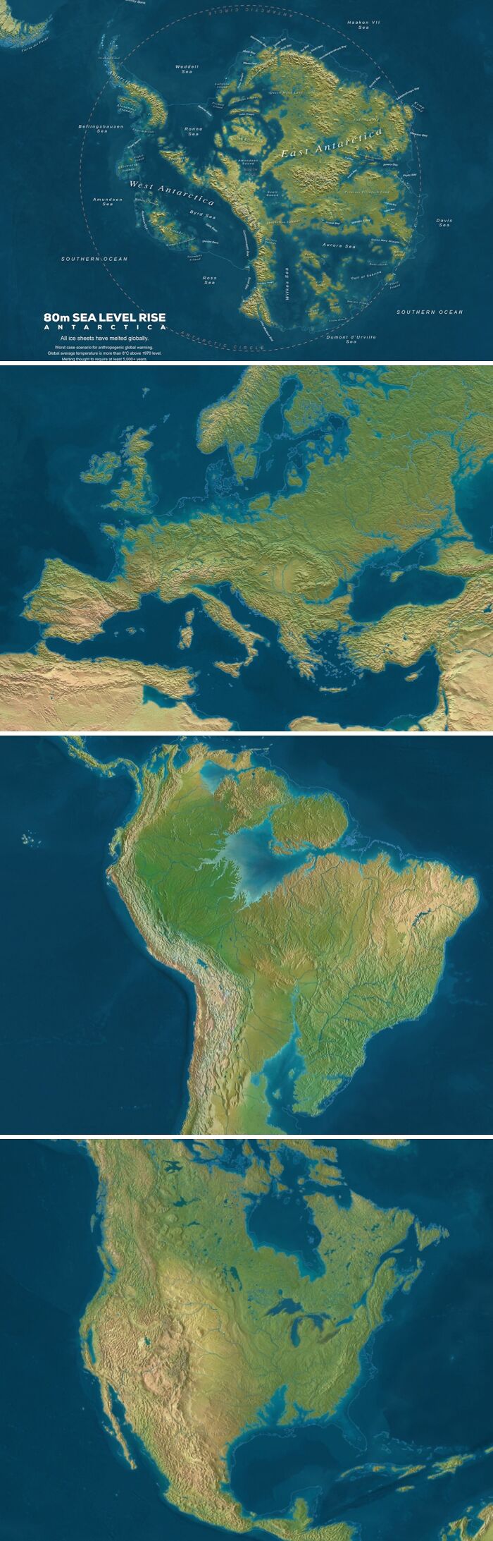
#25 Sea Level If All Ice Would Melt
© Photo: Ok_Bake_4761
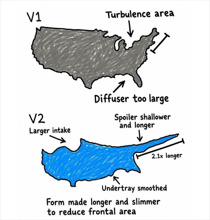
#26 Cyprus Is Just A More Aerodynamic Version Of The USA
© Photo: FunWithChaos0x
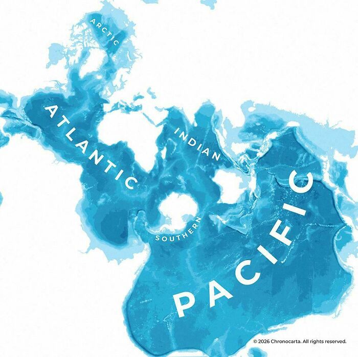
#27 Spilhaus Projection Is One Of The Most Interesting Ones To Map The World's Oceans
© Photo: RatioScripta
Irvine points to projections, “the geometry of it all,” as something that’s often unseen. The widely used Mercator projection, for example, stretches land the closer it gets to the poles. As Rob Lammle writes for Mental Floss, that’s why Greenland looks about the same size as Africa, when Africa is actually around 14 times bigger. And it isn’t only the shape of the world that gets skewed. “Bias is inherent within maps,” Irvine says. “You always need to ask what is shown, what is not shown, and how it is shown.”
#28 How Do You Say "Tea" In Europe
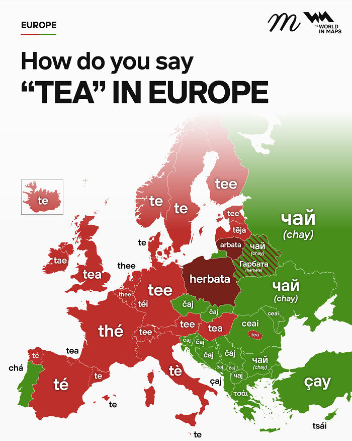
© Photo: maven_mapping
#29 Map Of The Seven Seas In Greek Sources
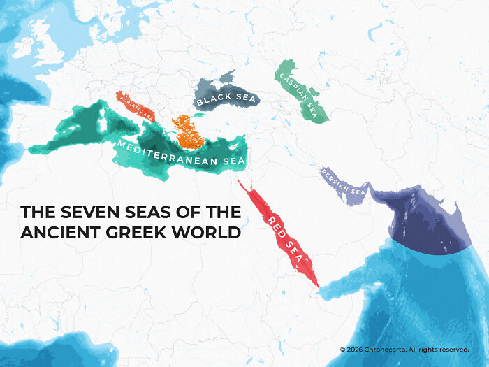
© Photo: RatioScripta
#30 "What Do You Call France?" ("France" In Different Languages)
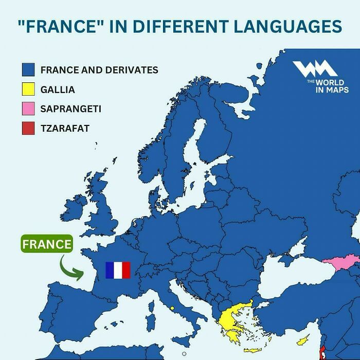
© Photo: SOHONEYSAME
Maps can also be deeply personal. Just think of Mason’s childhood maps—frogs and praying mantises and all. For Irvine, these are the most interesting kind. “The most exciting or interesting maps are the personal ones,” she says, “the ones that show a person’s psychogeography (the character and meanings that they attach to spaces) or their mental maps.”
So as you scroll through the maps below, enjoy the oddities, take a moment to notice what each one chooses to show, and maybe think about what your own map of the world would look like.
#31 The Largest Generation In Each Country
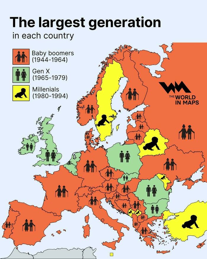
© Photo: vladgrinch
#32 A Private Company Once Controlled This Much Of North America
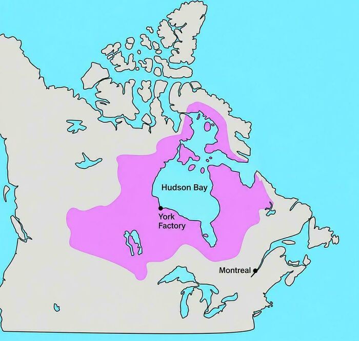
© Photo: vladgrinch
#33 Birth Rates In Pakistan Are Crazy
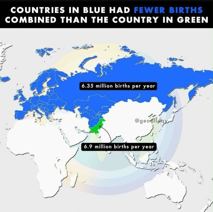
© Photo: julius-ceaser100
#34 US Rivers Drawn In Proportion To How Much Water They Carry
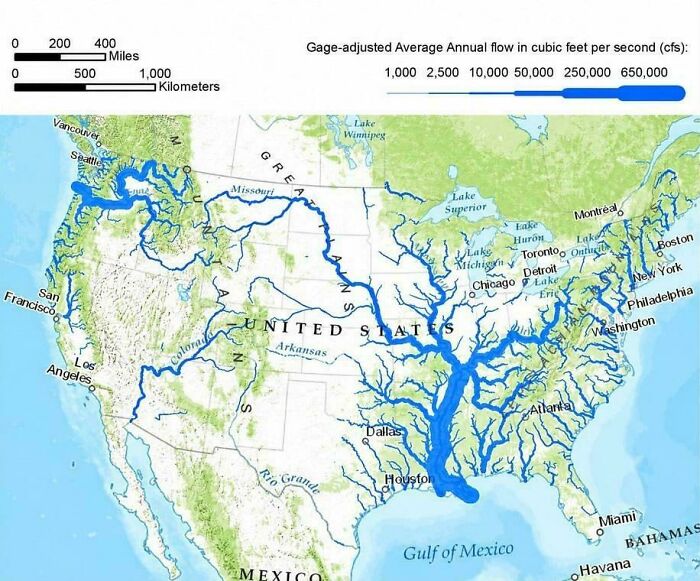
© Photo: vladgrinch
#35 These Three Places All Have About The Same Population Size
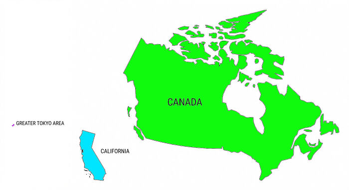
© Photo: KelVelBurgerGoon
#36 Range Of Palm Trees Across The World
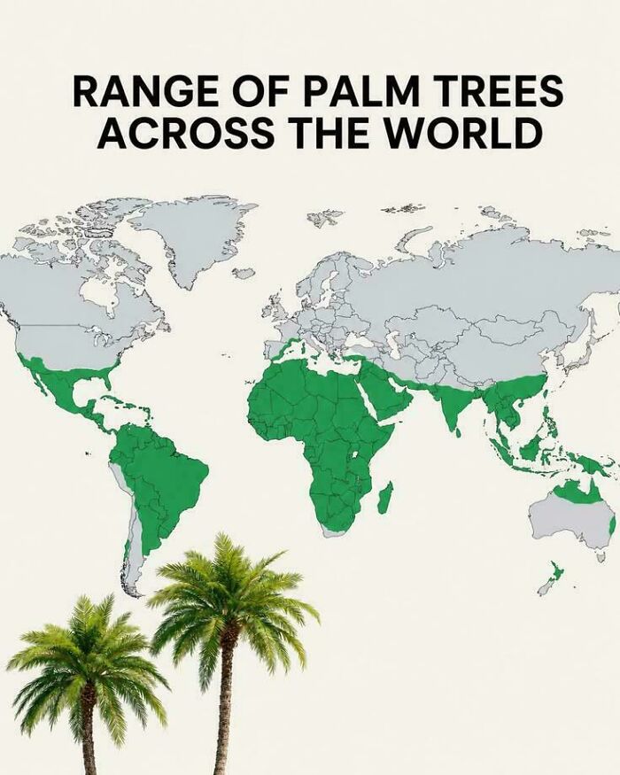
© Photo: AdIcy4323
#37 Trading Partners Of South America
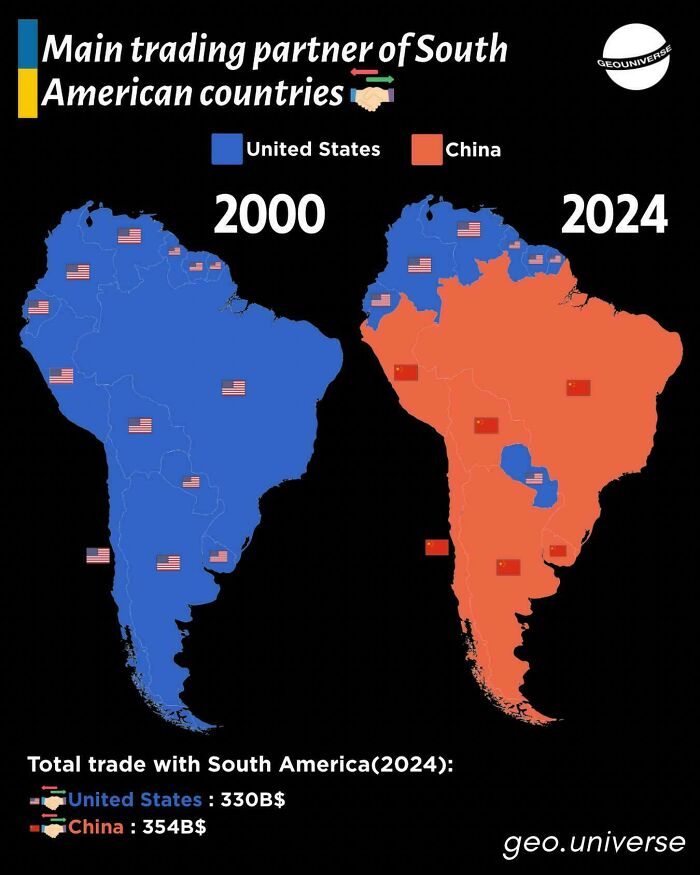
© Photo: Junior_Insurance7773
#38 The Northeast Megalopolis, Where A Sixth Of Americans Live
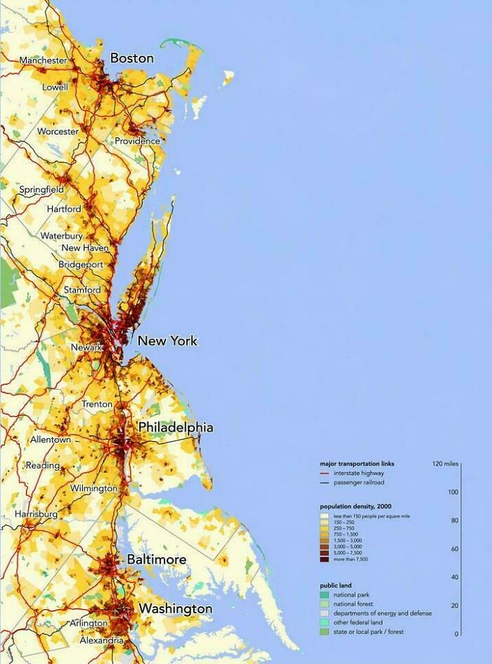
© Photo: vladgrinch
#39 Decimal Separators Used In Europe
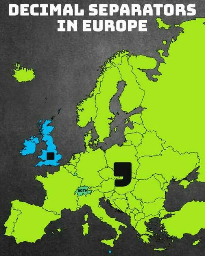
© Photo: vladgrinch
#40 Most Frequently Used Keyboard Layouts In Europe
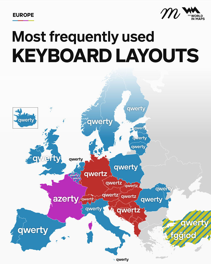
© Photo: maven_mapping
#41 Countries That Have Won The FIFA World Cup
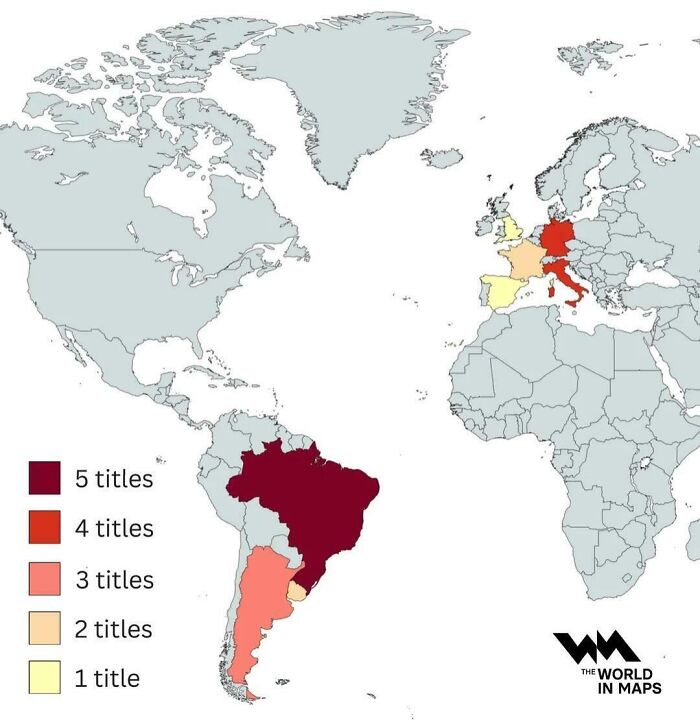
© Photo: vladgrinch
#42 How To Say Money In Different European Languages
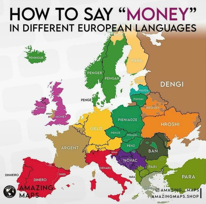
© Photo: vladgrinch
#43 More Than Half Of The World Lives In Just 7 Countries
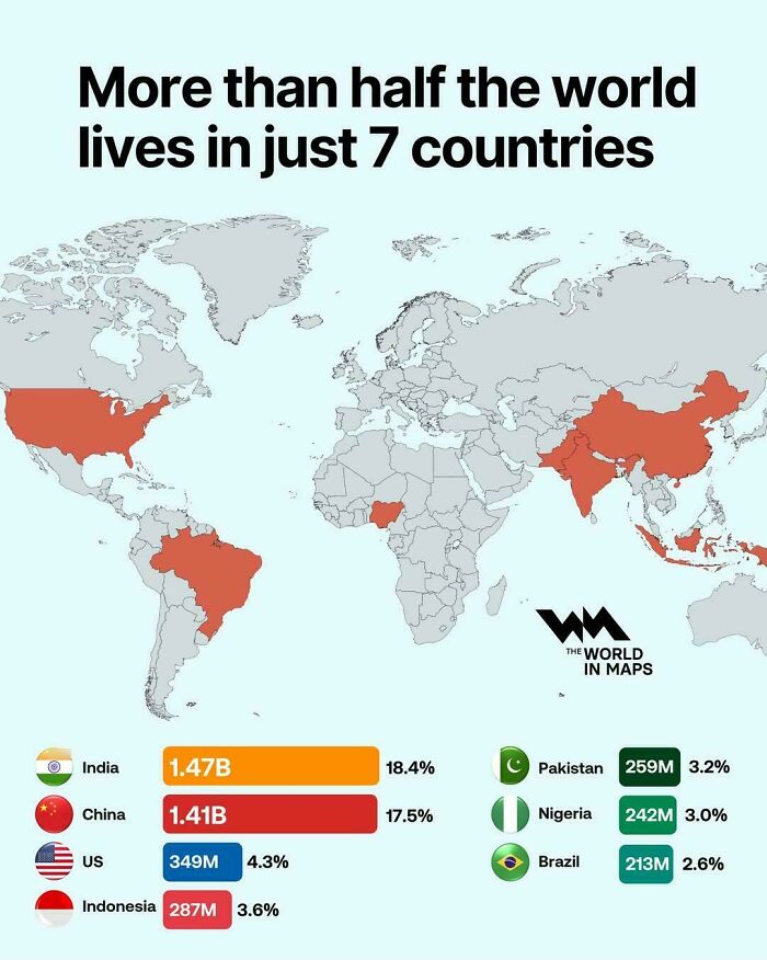
© Photo: vladgrinch
#44 Population Change In Greece & Turkey Over The Last Century
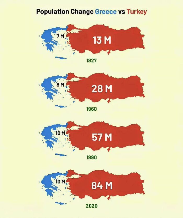
© Photo: Ripamon
#45 Europe On The Eve Of The French Revolution In 1789
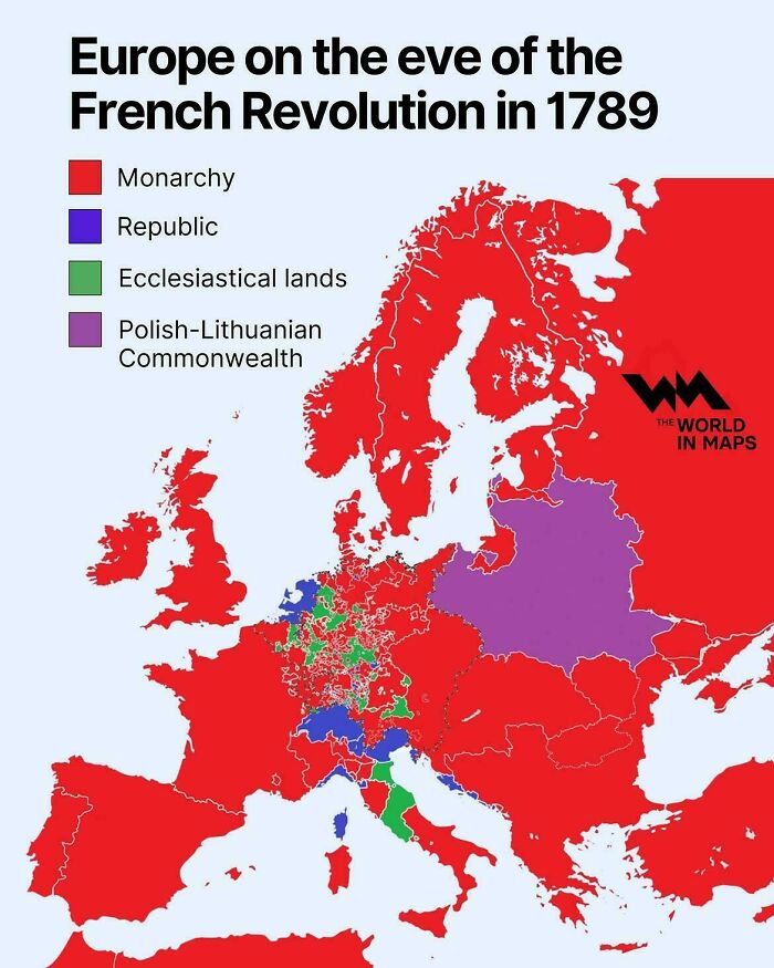
© Photo: vladgrinch
#46 The Journey Of Odysseus
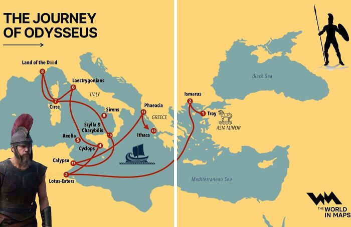
© Photo: vladgrinch
#47 The Same Number Of Brazilians Live In Each Highlighted Area
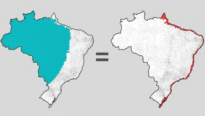
© Photo: vladgrinch
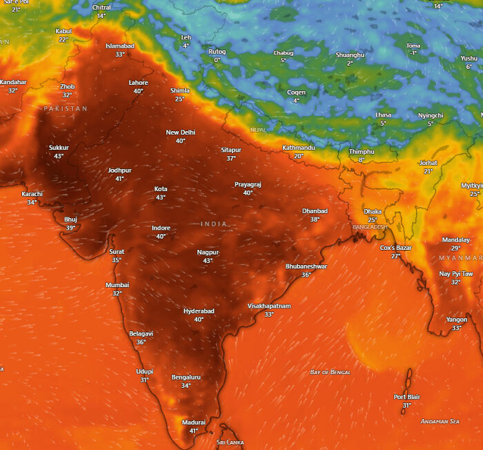
#48 A Map Of The Temperatures South Asia Is Facing Right Now. It's So Hot That I Can't Even Stand Outside For Over 10 Minutes In The Afternoon
© Photo: Asleep_Phone3087
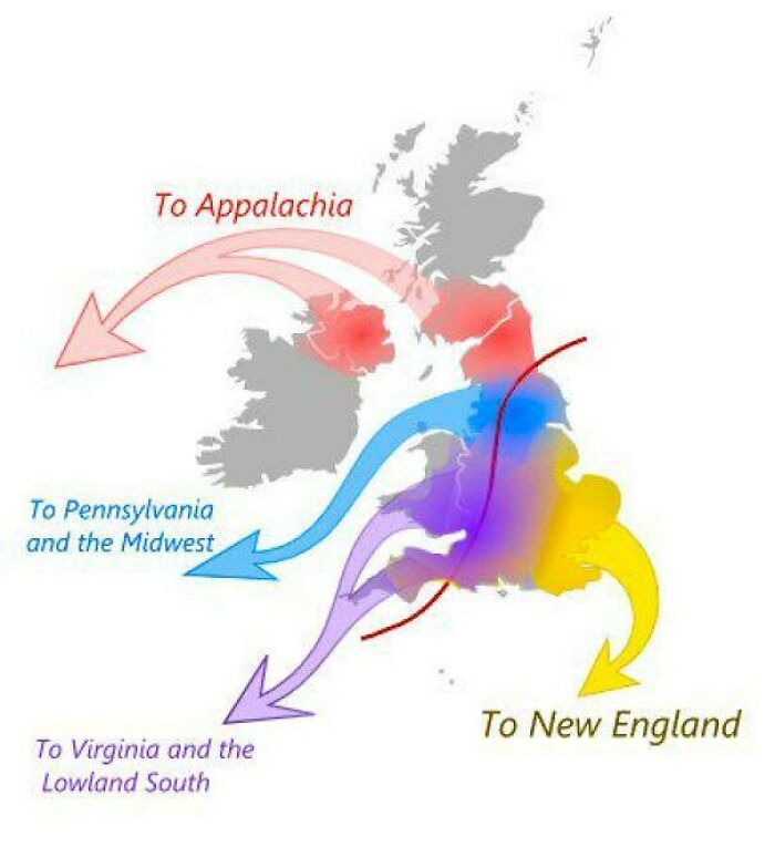
#49 The Migration Routes From Britain That Shaped Early America
© Photo: vladgrinch
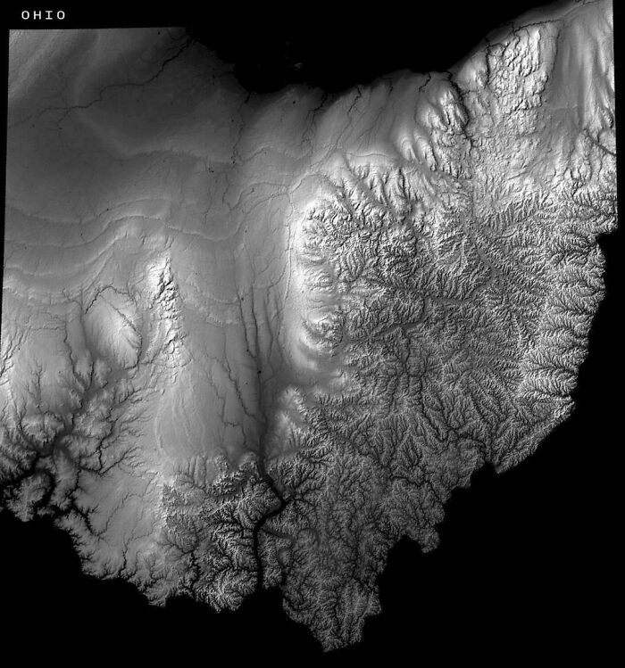
#50 Ohio's Elevation Map Reveals Where The Glaciers Stopped
© Photo: vladgrinch
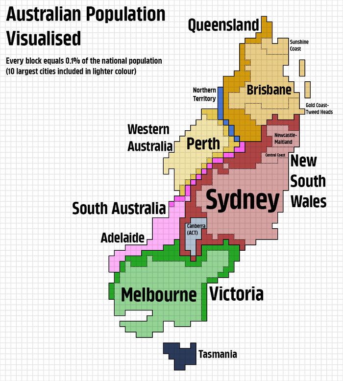
#51 Australian Population Visualised
© Photo: KaleyTheKing
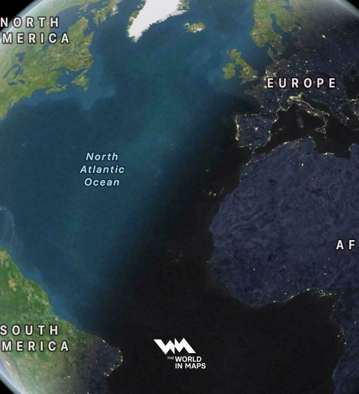
#52 On The Longest Day Of The Year, The Sun Sets In Eastern Brazil Before Ireland
© Photo: vladgrinch
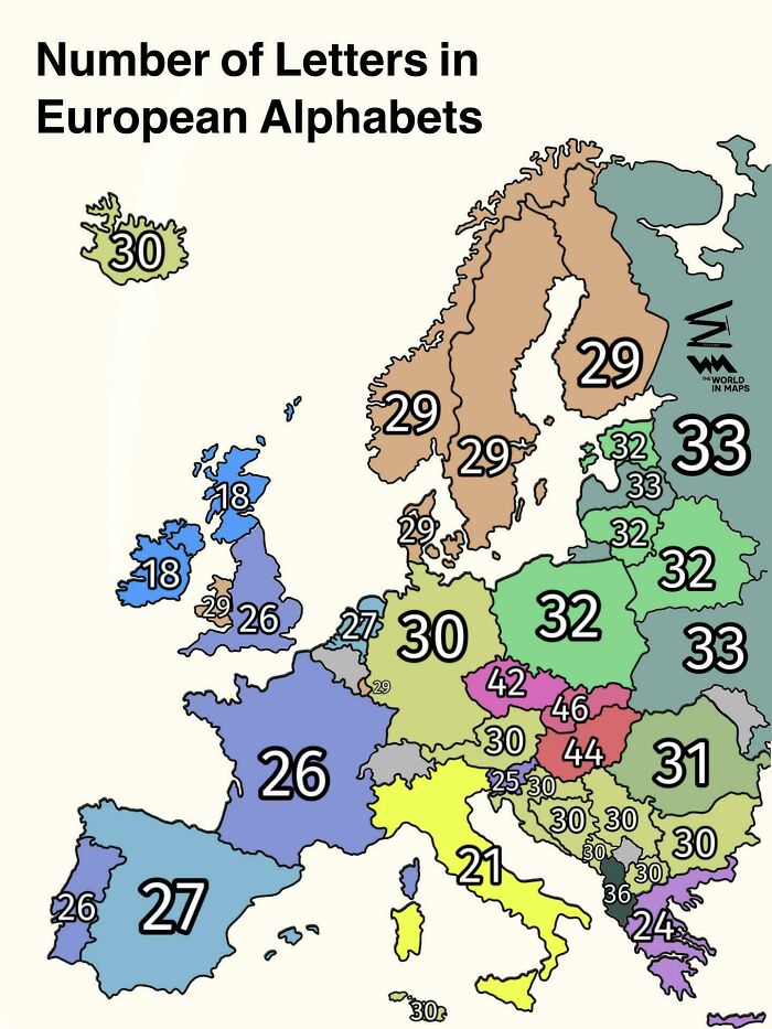
#53 Number Of Letters In European Alphabets
© Photo: vladgrinch
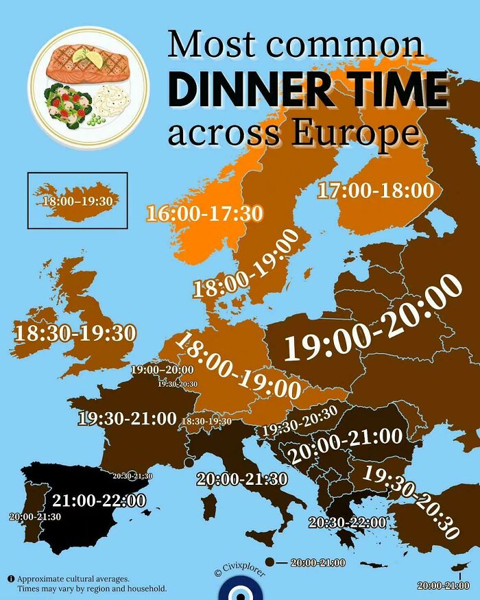
#54 Most Common Dinner Time Across Europe
© Photo: vladgrinch
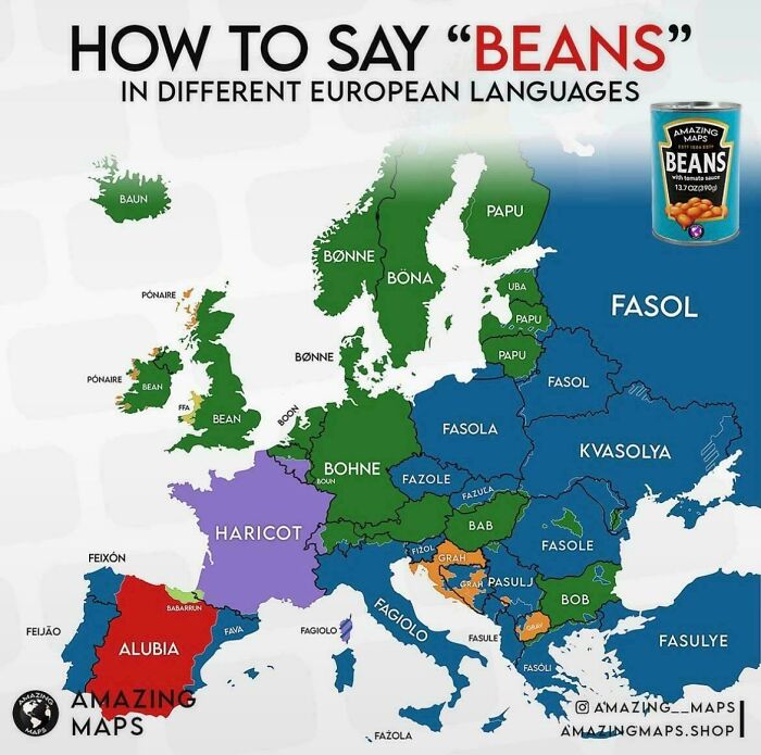
#55 How Do You Say "Beans" In Different European Languages
© Photo: vladgrinch
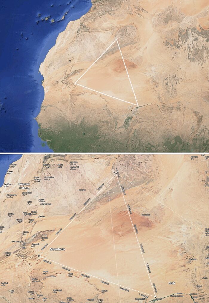
#56 This Big Triangle In West Africa Is Completely Devoid Of Humans. No Towns Or Settlements. More Than 1/5 Of Mauritania's Land Area Is In This Triangle
© Photo: SuspiciousUse6
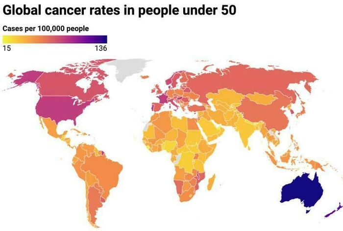
#57 Global Cancer Rates In People Under 50
© Photo: vladgrinch
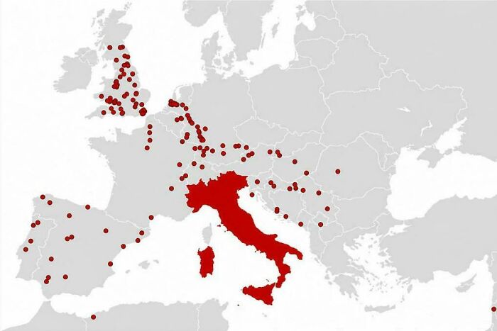
#58 Cities The Romans Founded Outside Italy
© Photo: vladgrinch
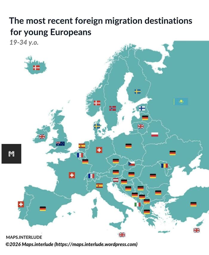
#59 The Most Recent Foreign Migration Destinations For Young Europeans
© Photo: quindiassomigli
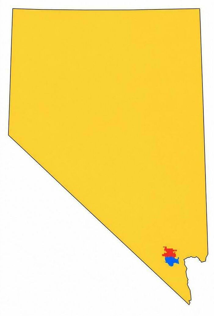
#60 Nevada Split Into 3 Areas Of Equal Population
© Photo: vladgrinch
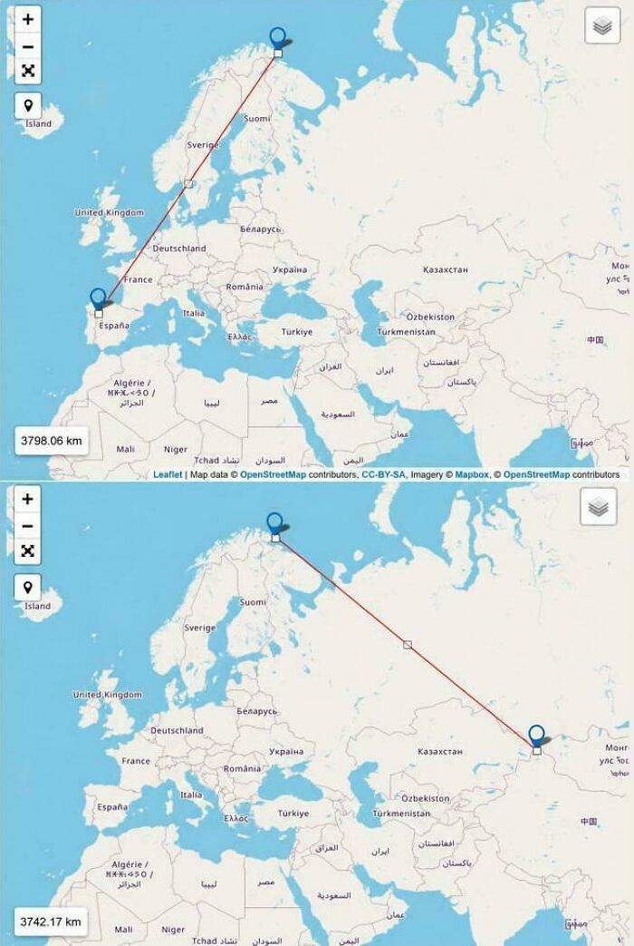
#61 From Vardø, Norway, It's Closer To China Than Portugal
© Photo: vladgrinch
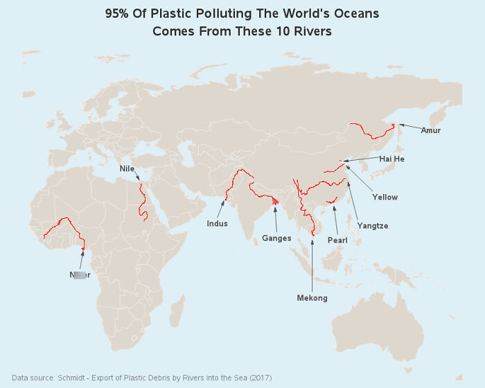
#62 95% Of Ocean Plastic Comes From Only 10 Rivers
© Photo: HelloWinterHello
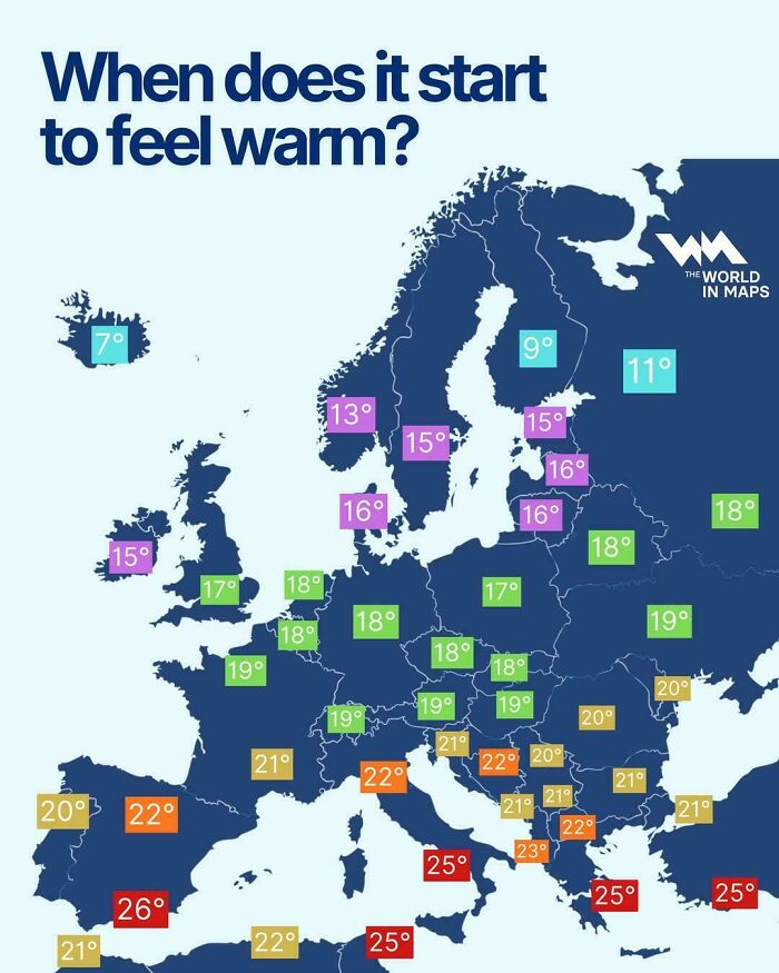
#63 When Does It Start To Feel Warm?
© Photo: vladgrinch
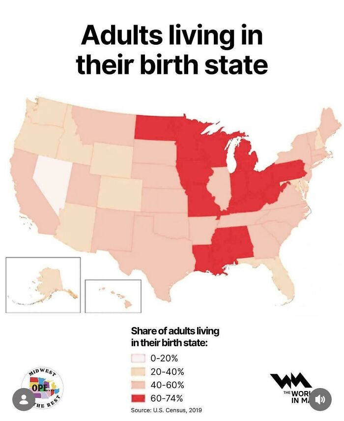
#64 Adults Living In Their Birth State (US)
© Photo: cardamomroselatte
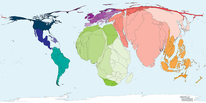
#65 World Map By Total Number Of Births
© Photo: julius-ceaser100
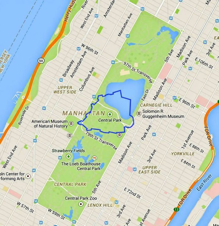
#66 The World's Smallest Country Compared To Central Park
© Photo: vladgrinch
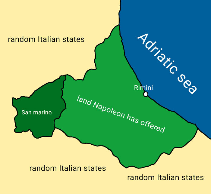
#67 Mapped The Exact Coastal Land Napoleon Offered To San Marino In 1797 (Which They Famously Declined To Avoid Making Enemies)
© Photo: anasazher
#68 The Shortest Driving Route Through All 48 Contiguous US States
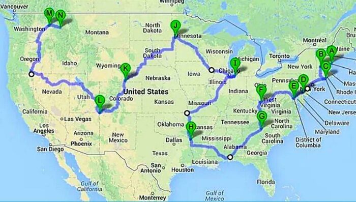
© Photo: vladgrinch
#69 The Shortest (Fastest) Road Trip Visiting All EU Countries, Find The Errors
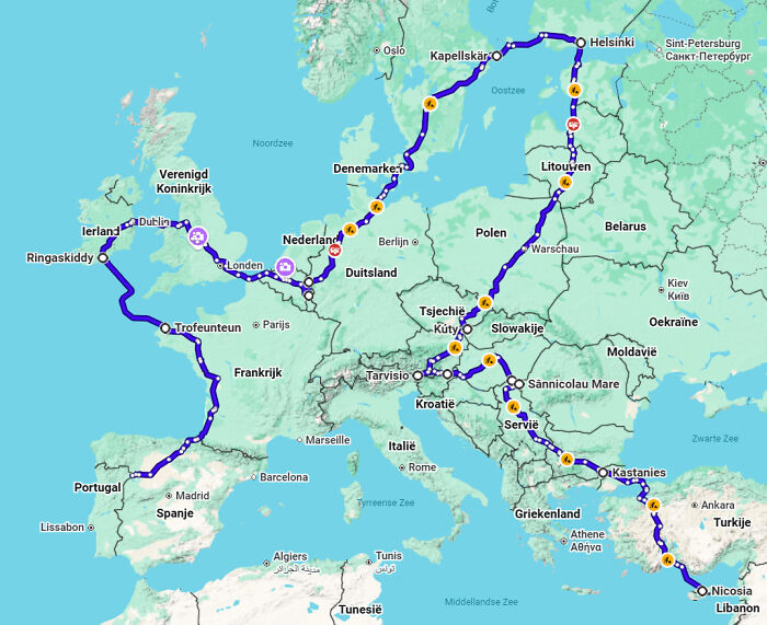
© Photo: Sad-Pop6649
#70 European Gold Medals At International Olympiads
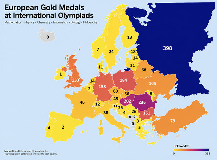
© Photo: DanDanCC
#71 Antarctica Ejects Anomalously Cold Temperatures Towards South America
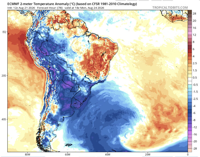
© Photo: Swimming_Concern7662
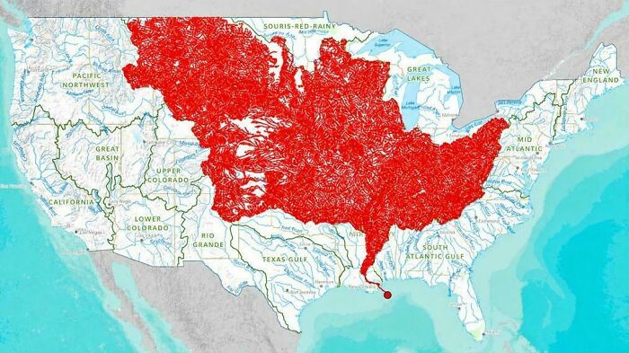
#72 The 7000 Rivers That Feed Into The Mississippi
© Photo: vladgrinch
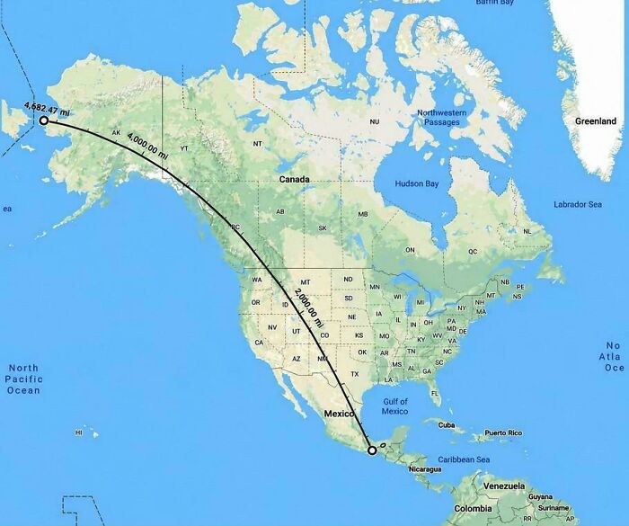
#73 The Longest Straight Line You Can Walk In The Americas
© Photo: vladgrinch
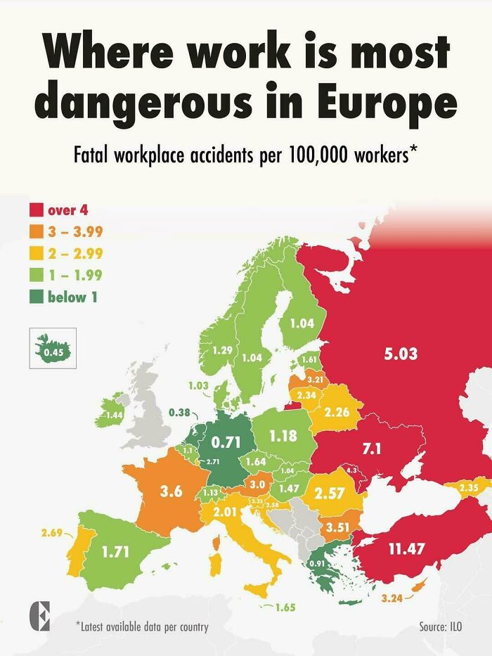
#74 Where Work Is Most Dangerous In Europe
© Photo: vladgrinch
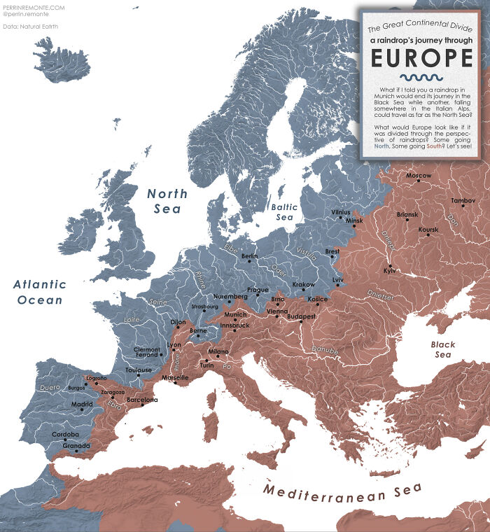
#75 The Great Continental Divide - Or A Raindrop's Journey Through Europe [oc]
© Photo: mydriase
#76 Countries That Have Won Eurovision, Split By Century
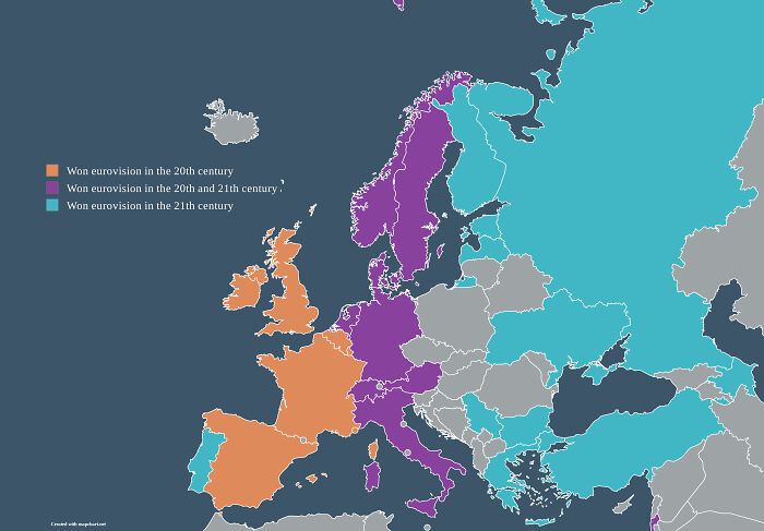
© Photo: Nearby-yourcat
#77 Europe's UFO Reports Map
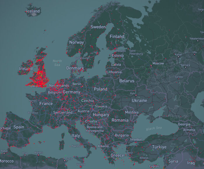
© Photo: BlokZNCR
#78 People Who Believe The Government Is Hiding A Cure To Cancer
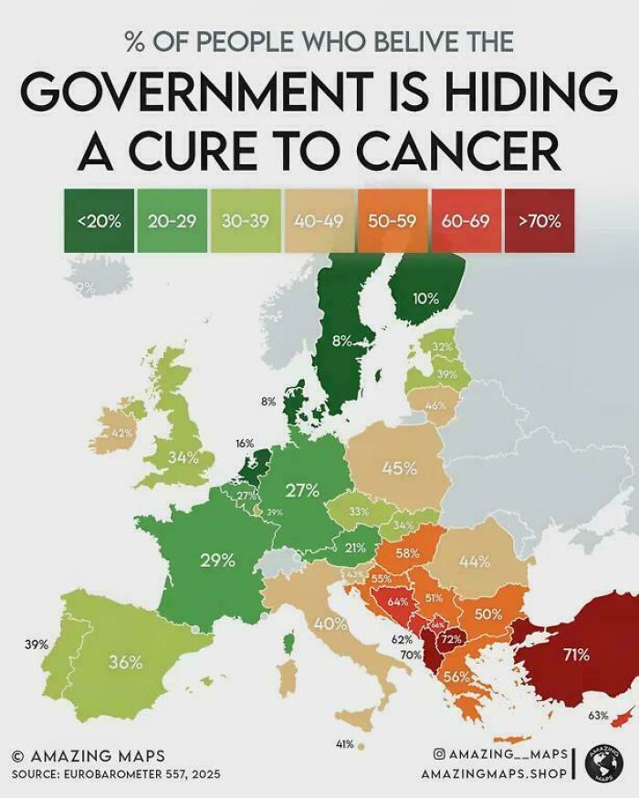
© Photo: milehiboy
#79 The Locations Of America's Ivy League Universities
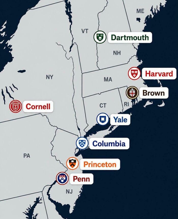
© Photo: vladgrinch
#80 Legal Obligation To Provide Free Tap Water In Restaurants
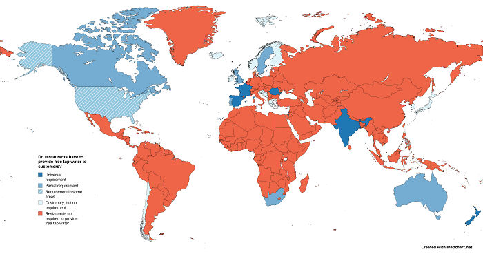
© Photo: MonotoneCreeper
#81 Lower 48 Area Within 1 Mile Of A Road
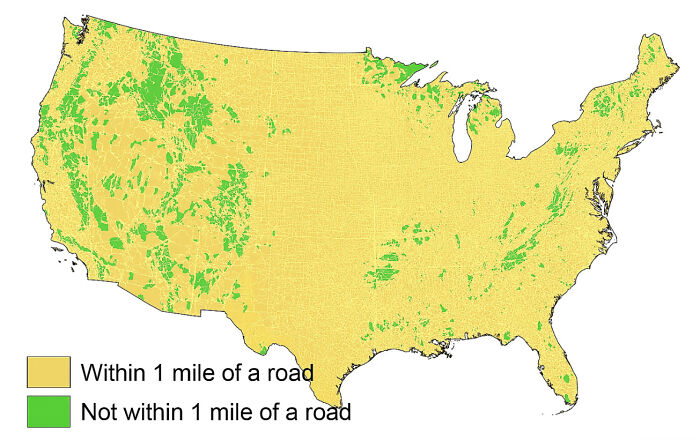
© Photo: medicallymiddleevil
#82 What Time Do Europeans Typically Wake Up?
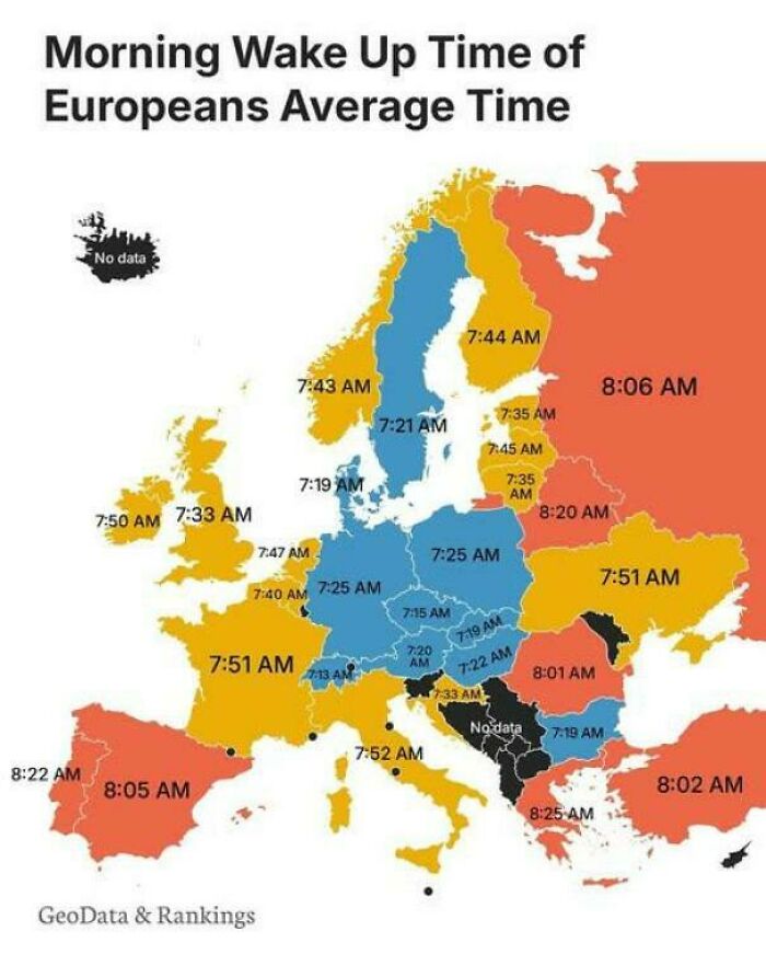
© Photo: vladgrinch
#83 I Mapped All 4.259 Aldi Locations In Germany (Nord vs. Süd Split)
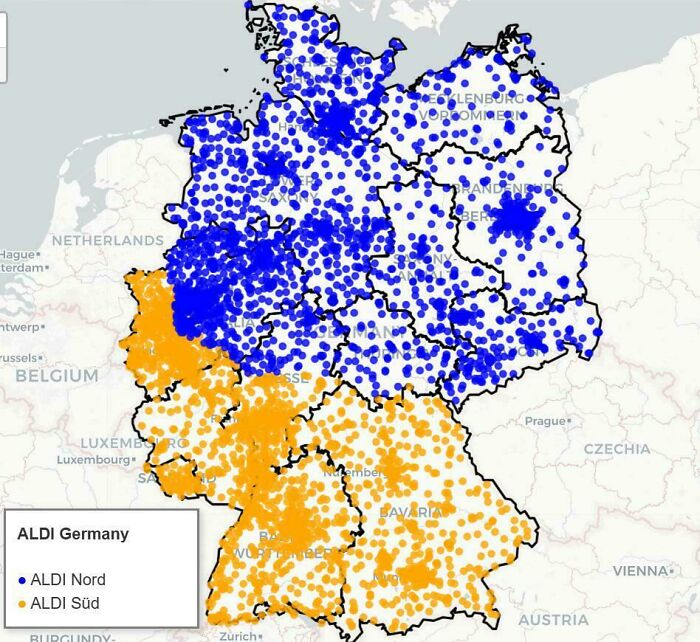
© Photo: Material-Soggy
#84 Legality Of Polygamy
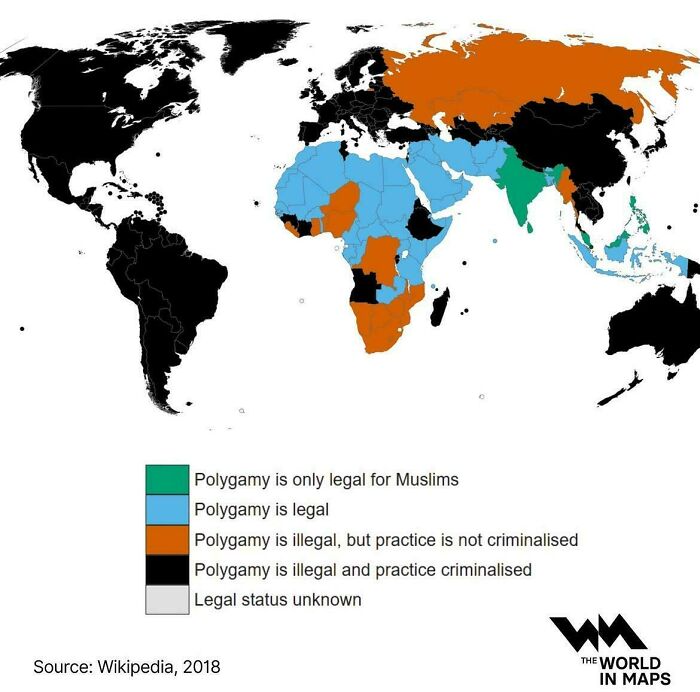
© Photo: vladgrinch
#85 Where Capitals Aren’t Economic Capitals
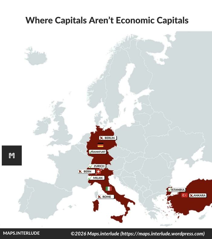
© Photo: quindiassomigli
#86 7/23 Busiest Air Travel Day In History
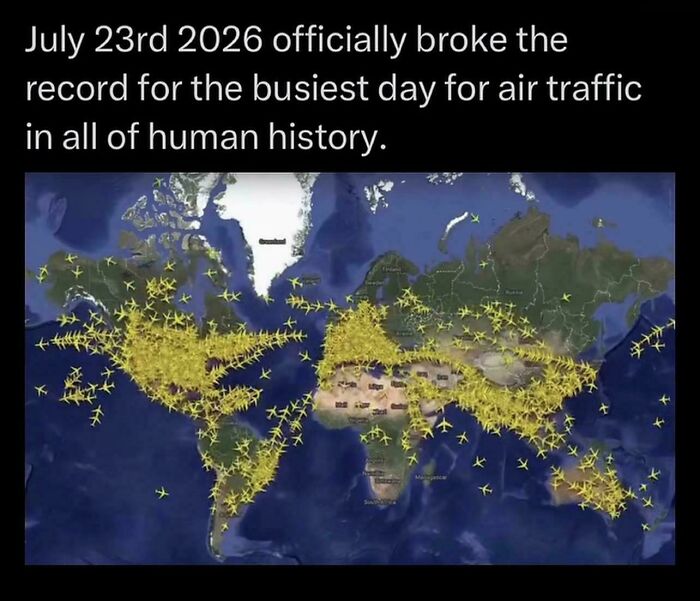
© Photo: ayachdee
#87 Minimum Gross Wage Across Europe
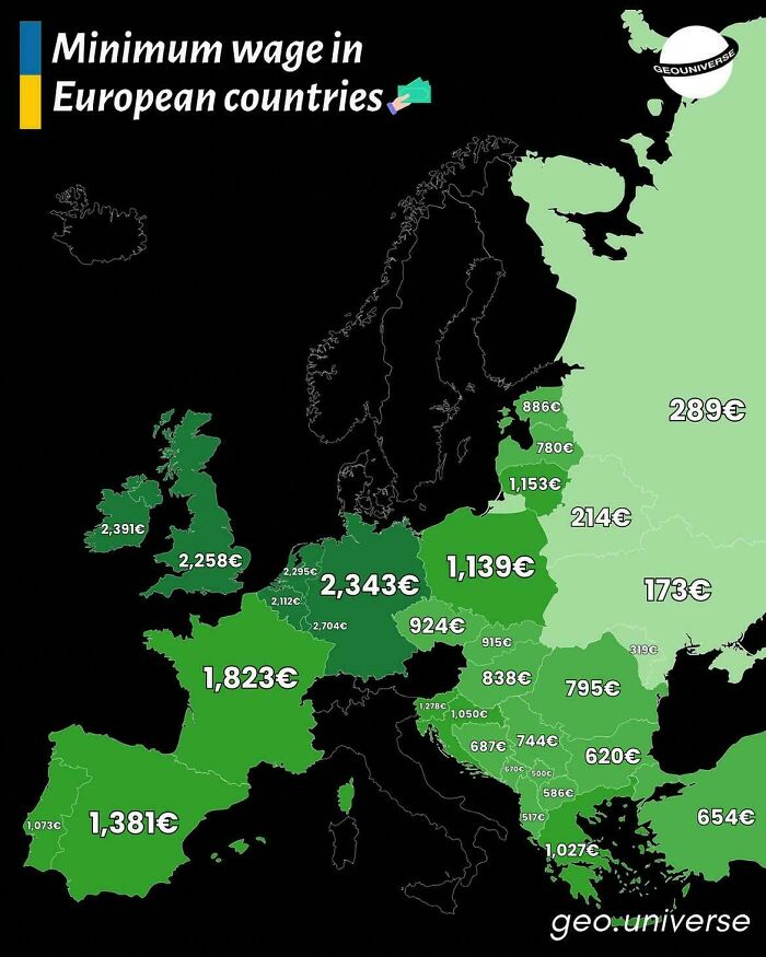
© Photo: vladgrinch
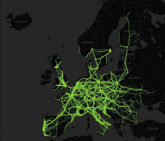
#88 Flixbus Services In Europe (As Of 2026)
© Photo: Mackelowsky
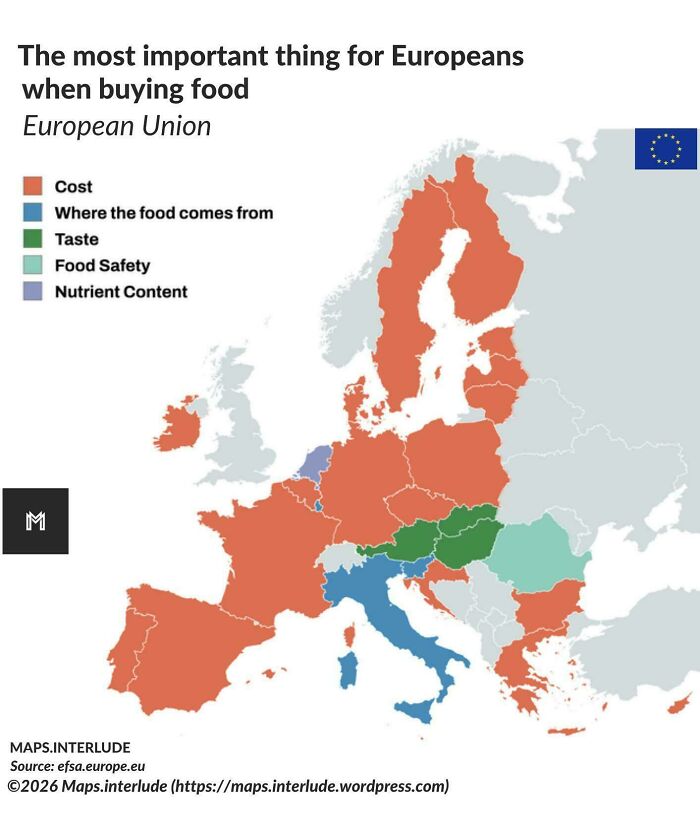
#89 The Most Important Thing For Europeans When Buying Food
© Photo: quindiassomigli
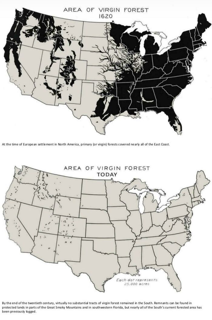
#90 Area Of US Virgin Forest In 1620 vs. Today
© Photo: catshifturr
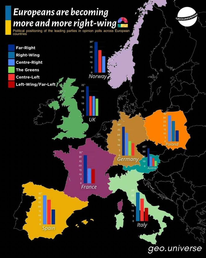
#91 Europeans Are Becoming More And More Right Wing
© Photo: vladgrinch
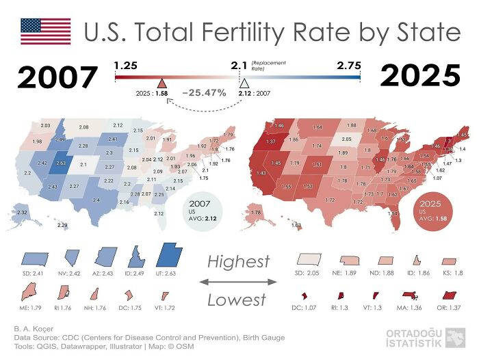
#92 Fertility Rate Of The US By State In 2007 vs. 2025
© Photo: Delicious-Bunch-6992
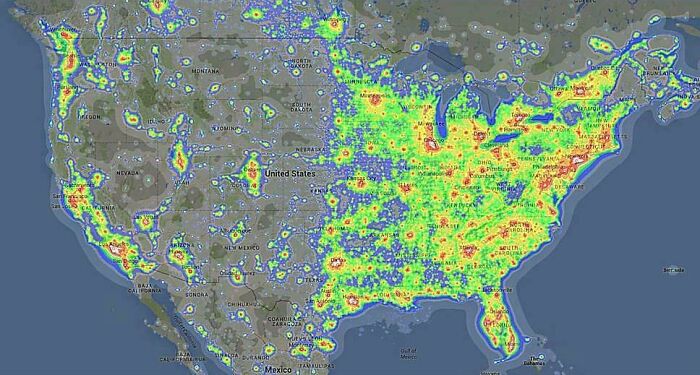
#93 Light Pollution Across The United States
© Photo: vladgrinch
#94 Number Of Hours Needed To Buy GTA VI
© Photo: maven_mapping
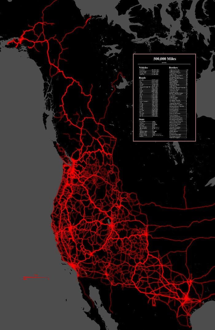
#95 I Spent The Last 7 Years Exploring The West
© Photo: EverestMaher
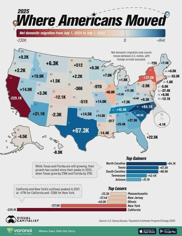
#96 States Where People Are Moving From And Where They're Moving To
© Photo: Dec8rs8r
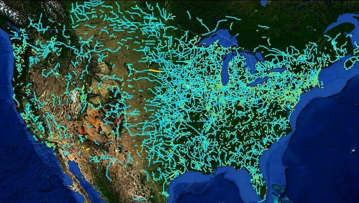
#97 America's Abandoned And Out-Of-Service Railroad Lines
© Photo: vladgrinch
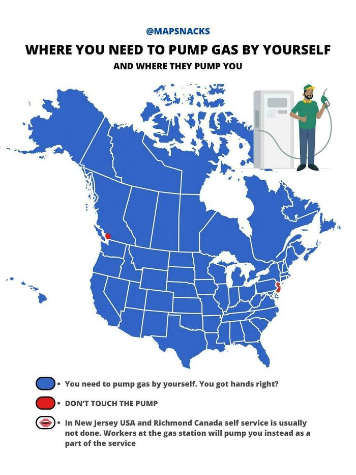
#98 Where You Need To Pump Gas By Yourself
© Photo: vladgrinch
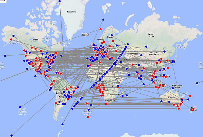
#99 Every Portal In Google Street View
© Photo: gantickwastaken